favicongohere
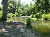

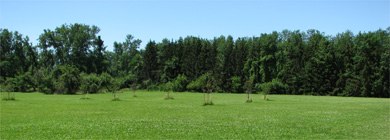
AMHERST STATE PARK


Please use the navigation menu at bottom the Page
MenuGoHere
Geological History of Amherst State Park
The earliest known history of life in Amherst was written, over 400,000,000 years ago, during the Age of Invertebrates in the Silurian periods.
Fossils found in sedimentary rocks of Western New York gave evidence that Crinoids, commonly called “Sea Lilies” (still living in the Indian Ocean) and “Eurypterids” (Sea Scorpions) which are closely related to scorpions and sometimes grew to six feet in length) lived in the warm shallow seas covering the area at the time.
Evidence in the Amherst area was exposed in the 19th century as quarries were developed to supply limestone for the construction of mills, homes, bridges and for ballast for railroads and canals.
In 1893, two perfectly matching imprints of the “Eurypterids” about a foot long, and numerous imprints of the Crinoids were found in the limestone of the Miller Quarry between Spring Street and Glen Avenue.
For more than a hundred years pure limestone was quarried in abundance from a ledge (Onondaga escarpment) that extends from east to west throughout the southern part of the town on a line just north of the present Main Street. (It is interesting to note that practically every street, running north from Main Street throughout Amherst today, runs downhill from this ledge.) Beneath this ledge a large layer of hydraulic limestone was also discovered, extensively quarried and burned for “water lime,” as cement was then called. .
Niagara Escarpment
The Niagara Escarpment begins in Watertown New York, and continues westerly along the Manitoulin Island in the Province of Ontario, Canada. It continues through Wisconsin and Illinios.
It is 1,005 miles in length and is the weathered edge of a very ancient sea bottom. Throughout its length from Hamilton, Ontario to Watertown, New York the escarpment ranges from 600 feet above sea level to 620 feet above sea level.
The Niagara Escarpment is the ultimate reason the Falls of Niagara was born. Without the escarpment, Niagara Falls may never have materialized. After millions of years, the Niagara Escarpment continues to erode in a southward direction.
The Niagara Escarpment was formed and existed before glaciations. The land that is now Southern Ontario emerged from the sea of the Paleozoic Era at least 245 million years ago or more.
.
Onondaga Escarpment
A smaller Onondaga Escarpment runs east - west is located along the northern shoreline of Lake Erie. Consisting of Onondaga limestone cap rock, this escarpment runs through Buffalo, New York and Fort Erie, Ontario. This escarpment is most noticeable east of Buffalo, however rarely rises more than 10 meters.
Substantial breaks in the Onondaga Escarpment have allowed Lake Erie waters to flow into the low lands of the Wainfleet Marsh 10,500 - 11,000 years ago and again 4,000 - 5,000 years ago during periods of time when the water level in the Erie Basin was much higher from the influx of waters from glacial Lake Agassiz.
Other physical breaks in this escarpment can be found at Lowbanks and Highway #58 in Port Colborne.
Between the Niagara Escarpment and the Onondaga Escarpment is a relatively flat and poorly drained lowland called the Tonawanda plain.
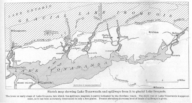
Glacial Lake Tonawanda
Glacial Lake Tonawanda was created with the retreat of the last Wisconsin Glacier. The lake was located east of the Niagara River. It covered the area between most of western New York and Rochester.
Although the lake was large in area, it had shallow water levels. The water along the eastern shore at Rochester, New York was only four feet deep.
At first Lake Tonawanda's only water outlet was the same as Lake Lundy, at Rome New York. Due to rising land in the east, this outlet was cutoff, forcing waters to seek other outlets.
Lake Tonawanda had a total of five water outlets over the 644 kilometer (400 mile) Niagara Escarpment. These outlets were located in Holley, Medina, Gasport, Lockport and Lewiston, all in New York State.
Only the outlet which became the main spillway was at Queenston - Lewiston. The draining waters flowed over the Niagara Escarpment and this is where the water falls of Niagara were born. This water course continues to be the main outlet which exists today.
Lake Erie was still very large, but the width of the Niagara River was much wider than it is today. The entire area where the Falls are today was under water. The water depth was 9 - 12 meters (30 -40 feet) and the slope, formed by glacial moraine, was on the west edge of Queen Victoria Park. Queen Victoria Park is where both the Skylon Tower and Minolta Tower are now situated. This was a river bank about 12,000 years ago before the gorge was created.
The retreating glacier was the main cause of the reduction in size of the much wider and much deeper glacial river known as the St. David's River. This transformed the St. David’s River into what is now a smaller and shallower river known as the Niagara River.
As the glacier retreated north, the water flowed to the much lower land which uncovered new land. This caused the draining of the Lake Erie basin and Lake Tonawanda. As these waters drained, the river became much smaller. This resulted in the discovery of land such as Niagara Falls, New York, Grand Island, Three Sisters Islands and Queen Victoria Park in Niagara Falls, Ontario.
the Ancient Seas' of Niagara
It is said that the Earth was created 4,600 million years ago. Ever since that time, the forces of nature have been masterfully creating an artwork of ever changing landscape and seascape known as Niagara.
Eons ago, the Niagara area the bottom of an ancient tropical salt water sea. Ancient specimens are being found today deep under the soils of Niagara that are still today found at the bottom of our great oceans.
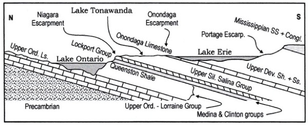
Schematic geological cross section through the western end of the Lake Ontario basin to the eastern end of the Lake Erie basin, showing the locations of the lakes relative to the southward dipping Ordovician to Mississippian stratigraphic succession

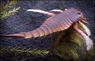
Reproduction of a eurypterid (Eurypterus remipes) from the National Museum of Natural History exhibit hall. Some eurypterids exceeded a meter in length, making them the largest arthropods. Most eurypterids probably preyed on other eurypterids or fishes and some may have been the dominant macropredator of the time. Photo by Chip Clark, NMNH.
Geology and Climate
During the Silurian, Earth underwent considerable changes that had important repercussions for the environment and life within it. Plate tectonic activity continued to shift the continents during the Silurian. The great southern continent of Gondwana drifted farther across the South Pole, while Siberia, Laurentia and Baltica clustered around the equator. Laurentia and Baltica collided at the end of the Silurian, forming a new supercontinent, Euramerica, and raising new mountain ranges. Rising sea level formed a nearly continuous sea from New York to Nevada, and other shallow seas still covered parts of other continents.
The Early Silurian was also a time of global icehouse climate that included great ice sheets at high latitudes. By the middle of the Silurian, however, global climate had become much warmer, comparable to that of most of the Ordovician and Devonian Periods. A new greenhouse phase began, leading to the melting of many large glacial ice sheets, which contributed to a substantial rise in global sea level. The result was a world with distinct north-south climatic zones, much as today. Glaciers remained at high latitudes, but lower latitudes were relatively warm and arid conditions led to the formation of extensive evaporite (salt) deposits near the equator.
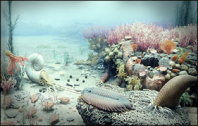
Reproduction of a typical shallow-water habitat with various plants and animals including crinoids, arthropods, and cephalopods. Silurian diorama by Terry Chase from National Museum of Natural History exhibit hall.
Photo by Chip Clark, NMNH.
aaaaaaaa
Articles in the news about the Geological History of Amherst State Park
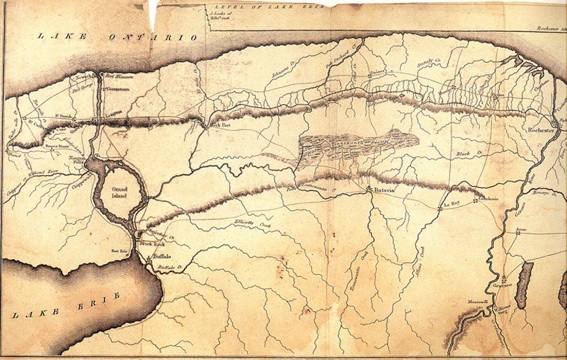
Erie Canal Map, western quadrant, date: post 1825
Niagara & Onondaga Escarpments
The Ordovician and the Silurian rocks of the Niagara Escarpment are of the oldest found in Niagara dating back to 430 - 415 million years ago.
The height of the Niagara Escarpment at Lewiston, New York is 250 feet.
Five kilometers west of Lewiston, New York, the escarpment is so steep that it rises 240 feet in 1/4 mile.
The eastern portion of the Niagara Escarpment is higher than in the west. The escarpment at Watertown, New York is 483 feet above sea level.
The ancient uplift and rising crust of the land in the eastern portion of North America is quite noticeable.
Only in Niagara can one find a gravel beach 483 feet above the nearest body of water
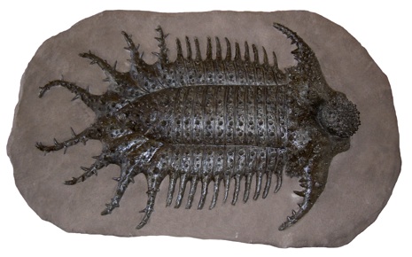
A full size reproduction model of
Terataspis grandis
A Trilobite that can be found in the Onondaga formation in W.N.Y.
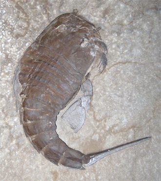
Eurypterus remipe
Eurypterid
Sliurian
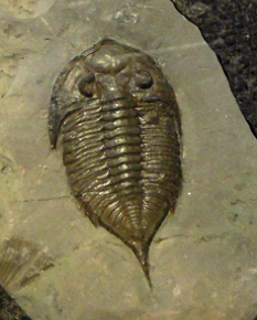
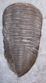
Dalmanites limulurus
Trilobite
Rochester Shale, Middleport, NY
Trimerus dephinocephalus
Trilobite - Rochester Shale
Middleport, NY
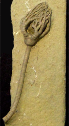
Cyathacrinites multibrachiatus
Crinoid
EURYPTERIDA - Extinct arthropods most closely related to the horseshoe crab, with a prosoma (head and thorax region with appendages) followed by an abdomen (twelve segments and a telson). Not very common, but included here because one genus (Eurypterus) represents the official New York State fossil
CRINOIDEA - crinoids or "sea lilies" - a group of echinoderms (starfish, sea urchins, and relatives). Usually includes a crown (main body or calyx with arms surrounding the mouth) attached to a long stem (column) that in many was anchored to the bottom by holdfasts or root-stocks. Body protected by calcite plates that usually separate after death; column composed of many plates (columnals) stacked together. At times crinoids were so abundant that their skeletal remains make up a major part of the rock in some formations.


AmherstStatePark.org
AMCNT Web Design Copyright 2011-15 ©
All Rights Reserved